A biking trail to honour a wise king
King Alfred is perhaps best known in popular mythology for burning cakes while sheltering in a peasant woman’s home, having fled Viking encroachments, and pre-occupied by weighty matters of the defence of his realm and people. Living from 848 (or it may have been 849) to 899 AD, and King of the Anglo-Saxons from 871 until his death, he should perhaps be better remembered as a wise, kind, and diligent monarch.

Statue of King Alfred in Wantage, the place of his birth in AD 848 (or maybe 849)
During his reign, he successfully pushed back the Vikings, creating Danelaw, and converted their leader to Christianity. He reorganised the Anglo-Saxon military system to provide much more rapid and effective defence against Viking attacks. But he did much more, reforming the legal framework and promoting education in the English language.
And now his name has been given to a wonderful new 350 kilometre, almost circular, cycle ride around much of the land of southern Wessex that Alfred once ruled. Mostly off-road, this trail links up a network of pre-existing routes and bridleways to create an extremely varied and quite challenging route that passes through some of Southern England’s prettiest countryside and many fascinating historic sites.
I rode ‘King Alfred’s Way’ in October 2021, blessed by a spell of mostly dry weather, which was fortunate as after rain some sections can get boggy (Surrey heathlands) or slippery (South Downs chalky trails). I pre-booked pub accommodation, which meant I had less to carry than would be needed for camping. These stays were also convenient for evening meals and breakfasts, and much more comfortable should it rain. It did mean I had to reach each day’s pre-planned destination, however, or I would have to find somewhere else and still pay as the free cancellation date (I used Booking.com) would have passed.
Covering the distance to my destinations was not usually that demanding in terms of cycling per se, but did place constraints on the time available for exploring historic places and beautiful landscapes en route.

Part 1 of my ride along King Alfred’s Way showing the full route, and the sections I covered on Days 1 and 2 from Wantage to Hindhead, along with my overnight stops and the main points of interest I saw and describe in the text
Overall, I took seven days of riding, with just six nights in paid accommodation as I was able to spend the start and finish nights with family in Wantage. My itinerary included a half-day ride from Warnford (in the valley of the Meon river) to Winchester to allow an afternoon to visit Wolvesey Castle (the old Bishop’s Palace) and the cathedral. I also planned a relatively short day to follow, so that I would have a couple of hours at Old Sarum. Frankly, another day or two for this trip would have been good.
The excellent Cycling UK Route Guide suggests two or three days for a very quick/quick circuit, and five days for a more leisurely ride. My experience (I am in my late 60s but not that slow!) would suggest that if you want to enjoy everything this fabulous ride has to offer, and like me are drawn to exploring history and spending a little time appreciating pretty villages and lovely views, then give yourself a few more days.
So here is my somewhat hastily recorded, day-by-day illustrated account of the King Alfred’s Way, a brilliant addition to the many great multi-day rides now available to bike-packers. This blog is in four parts (Days 1-2, Days 3-4, Days 5-6, and Day 7), each with maps (created by me in MapMaker 4 Pro), that show my route, along with my overnight stops, some of the most interesting places I visited, and a few other details. This article is Part 1, covering the route from Wantage to Hindhead (a small town at the top of the Devil’s Punchbowl). I filmed some video of the trail, and will add an edited selection of this at a later date.
Day 1: Wantage to Heckfield
Wantage lies just a few kilometres to the north of the Ridgeway, along which King Alfred’s Way runs. As I made final checks to my bike and kit, I thanked the bike-packing gods for the beautiful, cool morning and azure sky. Since I was departing from Alfred’s birthplace, paying homage to the man after whom the trail was named seemed appropriate, so I first headed into town to find his statue. Making a mental note to find out more about this king, and why he was called ‘The Great’, I sought out what I hoped would be a reasonably quiet route up onto the line of hills stretching across the southern horizon. A couple of rather brutal gradients on the B4494 warmed me up, and it was not long before I turned off the tarmac and onto the Ridgeway, heading east in the bright early morning sun.
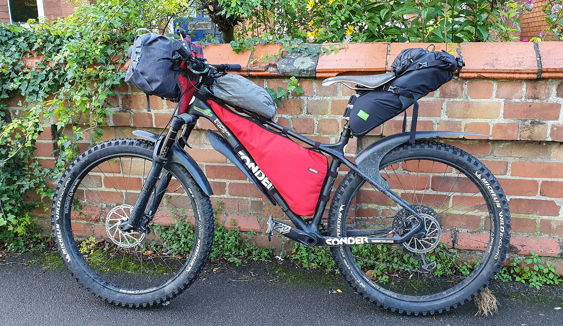
My King Alfred’s Way bike ready to depart from Wantage: a Sonder Transmitter Carbon with Michelin Wild Enduro tyres (chosen for muddy/boggy sections but perhaps a bit too ‘sticky’) and bike-packing bags. Yes, I was still carrying too much stuff!
The Ridgeway was lovely, with stunning views to north and south, and very peaceful. It dipped and climbed, then from Thurle Down the trail descended through a long wooded valley to Goring, a small and very pretty town that spans the Thames. So far, the cycling was quite easy, helped by mainly firm surfaces and recent dry weather.
King Alfred’s Way then runs south-east close to the left (north) bank of the Thames towards Reading, passing through some very pretty landscapes where I saw many Red Kites. I had not appreciated their calls before, somewhat like a buzzard but higher pitched, and purer. Just after the parkland at Hardwick House, the trail brought me to the quaint village of Mapledurham and I headed down towards the river to explore.
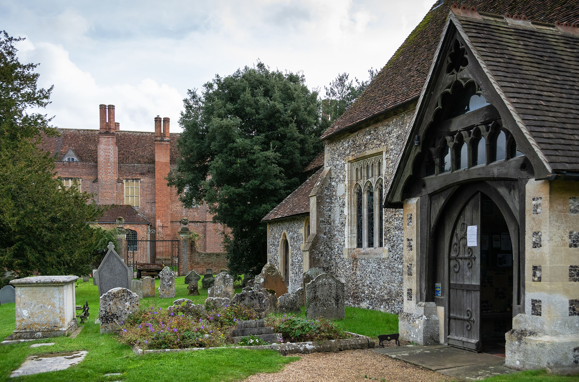
The remarkable site of Mapledurham village beside the Thames, with a mill, pretty stone and flint church, and an impressive Elizabethan manor house
Behind the lovely 14th Century flint and stone church stands Mapledurham House, an impressive Elizabethan manor that has remained in the ownership of the same family since building started around 1585. Nearby is a very old and picturesque water mill, the last one of its type on the Thames, still working and also producing electricity by virtue of a turbine. This fabulous setting has been used as a movie set, including for ‘The Eagle has Landed’ (1976), Miss Marple and Midsomer Murders, and some filming was in progress when I passed through the village. The mill featured on the cover of Black Sabbath’s debut album. Both house and mill can be visited at weekends and on bank holidays from April to September, so even if I could have spared the time (more on this in due course!), this option was not available to me.
Leaving the village, it was only a few kilometres from rural idyll to the busy urban world of Reading. Actually, the route of the trail through this substantial, former market town in Berkshire was rather fun. All credit to the KAW route planners, and those in Reading responsible for creating safe cycle routes.
To the Kennet and Avon Canal towpath
Once into the town the trail runs through a park close to the Thames, crosses the river to follow the towpath then drops a little past locks to the junction with the Kennet and Avon Canal. It is a bit of a concrete jungle hereabouts, an image softened by the grace of swans gliding across the water. The canal runs initially south-west, passing through the centre of the town, a lively area of shops, bars and restaurants offering many opportunities for a refuelling break.

The towpath of the Kennet and Avon Canal as it runs through the south-east suburbs of Reading
Further on, I followed the Kennet and Avon towpath through the quieter suburbs, with glimpses of charming gardens and plant-festooned decking belonging to homes lucky enough to back onto the canal. Soon I was wending my way through the commercial and business park to the south west of Reading, the trail passing gardens and ornamental pools. This area is overlooked by the 24,000 seat Madesjski football stadium which, as I passed by, stood impressively against an increasingly stormy sky. Named originally after the former Reading FC Chairman, it has recently been re-named to reflect the sponsorship of a car leasing company. Money talks.
A noisy interlude
By now I was feeling tired, light rain had started to fall, and I wanted to reach my destination about 15 kilometres further on in Heckfield. My mood was dragged down further by a somewhat scrappy section of trail, where I passed through some grim subways, past heaps of fly-tipping, and along a bridleway – nice enough riding in itself – that ran for some distance beside the A33 dual-carriageway where my thoughts were drowned by the constant roar of traffic. Seeking peace and quiet, I diverted off the official route briefly through Swallowfield and Riseley, then followed the B3349, scarily busy with impatient rush-hour drivers, southwards to the New Inn at Heckfield.

My first overnight stop – the New Inn, Heckfield, where I was well looked after. I was offered a hose to clean my bike and a safe area to store it overnight. In fact, all of the places I stayed were very welcoming to cyclists
The pub was very quiet on that wet Monday evening, but the friendly welcome soon lifted my spirits. I was offered a hose to clean my bike, and shown a ‘conference suite’, temporarily out of use due to the coronavirus pandemic, to store the Sonder safely overnight. Snug in the bar with the KAW guidebook, camera, and GoPro, I looked back over my first, extremely varied day and began jotting some travel notes. I was beginning to appreciate how this route, cleverly stitched together from well-established longer-distance routes, available bridleways, and a few quiet lanes, would take me on a wonderful and surprising journey of discovery through a southern England that I mistakenly thought I knew from all too familiar place names.
Day 2: Heckfield to Hindhead
Fearing the morning rush-hour would be a repeat of the previous evening on the main road leading back to where I had left the KAW, I took a minor road from near the pub, crossed the River Whitewater and re-joined the trail near Bramshill. On the bridleway in the forest, a couple of horse riders asked if I was riding King Alfred’s Way, commented on the wet conditions, and wished me well. That was to be the first of several such encounters today. Again, clever of the route planners to find a safe bridleway beside the road.
Back onto a quiet lane, I headed towards the RSPB reserve of Hazeley Heath, one of several heathlands I would cross on this section of the trail. As I paused by a stream to take some photos of the beautiful morning light, a lady stopped her car, wound down the window, and she too asked if I was riding the KAW. She ran a coffee shop nearby that would have been open but for Covid, but in any case it would have been a bit too early in the day for me to take a break. Next time, maybe.

Hazeley Heath in Hampshire, one of several beautiful lowland heaths on this section of the King Alfred’s Way, and which can be hard going due to the sandy soil and often waterlogged paths
On its website, the RSPB describes the heath thus: ‘Hazeley Heath is a fine example of lowland heath, more than 75 percent of which has been lost from the UK over the last 200 years. This tranquil reserve is home to some very special wildlife, such as nightjars, tree pipits, woodlarks, and silver-studded blue butterflies.’ I set out along a winding trail that was very, very wet, some of it completely flooded and hard going, until I emerged onto a lane passing though more open heathland. The light was stunning.
This is a very beautiful part of the country, though I feel bound to comment on what else struck me as I rode along ancient bridleways and quiet lanes connecting the hamlets and villages. The wealth here is staggering. There are so many large (and very large), gorgeous properties, in extensive grounds, with paddocks and horses, and everyone seems to have at least one or two Range Rovers or similar vehicles. I live in Cheshire, a county with its own share of very wealthy residents, especially around south Manchester. But here it seems to be on another level, long-established and part of the fabric of the countryside and its communities. Seeing this concentration of immense wealth close up really does emphasise the social divide in this country. I imagine too, that most of these families educate their children in the private sector, contributing further to the ‘apartheid’ of cultural values, expectations and much else which I believe to be among the most fundamental problems of British society. But seeing this wealth also reminded me of my own good fortune in being able to spend a week riding a good bike around this trail, staying and eating in pubs, and so on, when many others are going to food banks and struggling to pay for energy and other necessities.
There is just so much to see!
In the woods near West Green, I found a carved wooden snail on a post, and this seemed to offer a metaphor for my pace so far today. I was not dawdling, but was stopping frequently to enjoy my surroundings. This was the start of my anxiety about progress, however, as I had to reach Hindhead and there was a lot to ride and a lot to see along my route for the day. For example, this area is littered with the remains of Second World War defences, including tank traps and ditches. I found some of these in the form pyramidal concrete ‘dragons teeth’, beside a railway bridge to the east of Hook. Just south of the M3 motorway, the crossing of which rudely reminded me of the crazy world I was escaping from, I opted to ride along the Basingstoke Canal. There is a road option in the Guide, but I found the towpath easy and delightful to cycle along.

Second World War ‘dragons’ teeth’ anti-tank defences by a railway bridge near Hook, one of quite a number of war-time remnants to be seen along this section of King Alfred’s Way

The Basingstoke Canal at the point where the King Alfred’s Way leaves to towpath near Winchfield Hurst
After a coffee break at the Queen’s Head pub in Dogmersfield, the trail took me back to the canal with one crossing via rotating swing bridge. I live in canal country, but had never seen one like this and, having spotted an approaching boat, decided to wait so as to see (and video) the bridge being opened. The two men operating it had to put some effort in, but it glided around easily enough.

The unusual rotating swing bridge over the Basingstoke Canal just to the south of Crookham Village
As the King Alfred’s Way trail skirts Fleet and heads for Farnham, it was hard to believe I was riding though such a busy part of southern England, less than fifty miles from Central London. I was also passing the first of several Ministry of Defence training areas, with their warning signs. What with the later crossing of Salisbury Plain, this ride has many echoes of King Alfred’s military organisation and preparedness back in the 9th Century AD.
From the Civil War to WW2
Farnham castle is a rather delightful wedding venue, and the Norman fortress has an interesting history that is worth a visit if you have time. Built in the 12th Century, the castle featured during the Civil War, falling to the Parliamentarians in 1642. From the mid-18th Century, it became the favoured base for the bishops of Winchester, who mediaeval palace (known as ‘Wolvesey Castle’), I would visit on Day 4. Much more recently, during WW2, it was used for camouflage research. I cycled up to the entrance courtyard and sneaked a look at the lovely grounds, but decided that, even though I am a member of English Heritage and could have made a rapid visit for free, I just had to keep moving. I was determined to visit Waverley Abbey, another English Heritage site just south of Farnham, so grabbed some sandwiches and fruit from Sainsbury’s and left the town by another rather sombre underpass.

Farnham Castle, a 12th Century Norman fort that later saw action in the Civil War; parts of the castle can be visited (English Heritage) and it also serves as an attractive wedding venue.

The not very salubrious A31 underpass on the way out of Farnham
Shortly after leaving Farnham and passing through the rather grim A31 underpass, one is supposed to take a diversion along a road through the high-end Moor Park Estate, rather than the more direct (and less hilly) track (still a footpath, rumours of it reverting to bridleway status so far unrealised) that runs close to the River Wey. I ‘accidentally’ took the path that is not (yet) a bridleway, as I wanted to see some of the WW2 remains, part of the so-called ‘GHQ Line’ defensive system. Also I thought it would be quicker, which it would have been if I had not stopped to explore bunkers and take photos – swings and roundabouts.
Tranquil ruins beside the River Wey
I was really feeling the pressure of time as I sat beside the abbey ruins trying (and failing) not to wolf down my sandwiches. Looking ahead, the KAW Route Guide encouraged me not to miss Frensham Common, even though a short-cut would save quite a lot of time (and climbing). I decided I would ride that section, whatever the time, as it looked too good to miss. I had a decent set of lights, and my destination pub in Hindhead would be open till late. I did not want to miss dinner, though. Que será, será.

A vaulted section of the west range of Waverley Abbey, and one of the best preserved sections
Despite my anxiety about the time, I diverted briefly through Tilford as it was described as very pretty, and it was – with a very inviting looking pub on the green. The next highlight was the wooden footbridge over the River Wey at Pierrepont; there was a ford too, but the river was too deep and fast flowing to attempt that.

The wooden bridge over the fast-flowing River Wey at Pierrepoint, just north of Frensham Little Pond
The Wey river crossing brought me out on the north side of one of the Frensham ponds, this being the ‘Little Pond’. A left turn would have taken me quickly via the short cut to Rushmoor. While this was tempting, I kept my resolve and headed west and then sharply to the south-east to climb a sandy track up onto Frensham Common. And I am so glad I did. From the high point of this National Trust owned Site of Special Scientific Interest (SSSI), there were wonderful views in all directions, including of the Great Ponds across which I was treated to a dramatic late afternoon light. It is a haven for wildlife, with some rare species, while the ponds themselves were created in the 13th Century to provide fish for the Bishop of Winchester and his court. I would be visiting the remains of his palace a couple of days later.

Dramatic late afternoon light over Frensham Great Pond, on a lovely section of the trail crossing sandy, wooded heathland owned by the National Trust and a SSSI
An interesting descent, not too technical but fun nonetheless, ran south and then around to the east side of the common, where another ford at Lowick (thankfully also with a footbridge as this stream was quite deep) brought me to Rushmoor. This was another wooded area of up-market homes, many with large gardens, paddocks, and horses, and served by unmade-up roads. It reminded me of Karen, the very wealthy neighbourhood on the edge of Nairobi below the Ngong Hills, and named after Karen Blixen whose farm was located there.
I had two more objectives for the day, apart from reaching my hotel, namely the Atlantic Wall and the long (and in places) very steep climb through the impressive feature in these Surrey Hills known as the Devil’s Punchbowl.
A test-bed for the D-Day landings
The Atlantic Wall was not far away now, just a couple of kilometres ahead on Hankley Common. This was a high reinforced concrete wall built in 1943 to test explosives and assault equipment, including so-called ‘funny tanks’ developed to deal with the German coastal defences in northern France. You will not miss it, as it is still a very substantial structure, lying just to the south of the main track across the common.

The remarkable ‘Atlantic Wall’ at Hankley Common, built during the second World War to test equipment and techniques for overcoming the German coastal defences in northern France
And now for the Devil’s Punchbowl. After a brief rest and snack, I set off up the small lane running south from Thursley in the gathering dusk. After a couple of kilometres I reached a junction where the track became loose and stony, climbing steeply up an ancient track overhung by dense trees that left me in almost total darkness. Even with my light, I struggled to keep balance, so decided to walk for a while – it would have been no quicker to ride. After five hundred metres or so, the gradient eased, and the trees thinned. Ahead I caught sight of a deer in my light; it moved cautiously towards me for a few metres, then bounded off to the side of the track. To the west, the clouds had parted revealing an orange glow from the setting sun, while a cool, strong wind blew through the trees, adding to the magical atmosphere.

On the long, steep climb to the Devil’s Punchbowl rather later than planned, as there had been so much of interest to see earlier in the day. Despite, or perhaps because of, the hour, it was a magical experience.
The cycling became a lot easier as I neared the top of the Punchbowl, and keen as I was to reach the hotel, I was also reluctant to finish this wonderful section of the trail, made all the more special by the light, wind and peace of the evening. My busy day saw me riding this section in the fading light of dusk, but that left impressions that made this one of the most memorable sections of my ride along King Alfred’s Way.
Another friendly welcome greeted me at the Devil’s Punchbowl Hotel, along with a safe indoor room to keep my bike. Several other bikes were already stashed there, and I decided to seek out their owners in the bar to see how they were getting on. First things first, however – food. Covid and Brexit-related staff shortages meant there was no dinner on offer at the hotel that night, but a fish and chip shop around the corner was open, and the pub staff were only too happy for us to bring the food back to the bar.
Tales of navigation on King Alfred’s Way
I joined a young couple riding the route on gravel-type bikes. We talked about the challenges of navigation, and agreed it was not always easy. They were using the GPX download of the ride on their Garmin devices, but told me that route finding was still not always straightforward. I was not using a GPX file to navigate, but was instead relying on the sections of 1;50,000 Ordnance Survey maps in the Route Guide, along with the Ordnance Survey (OS) App on my phone to find my exact location when needed. That worked really well, as the OS app could scale to 1:25,000 so it was always easy to find precisely where I was. None of the KAW is waymarked as such, and navigation can be quite tricky in some places without one or other of these navigational aids. On other sections that follow established long-distance routes, such as the Ridgeway or South Downs Way, it is very easy, so long as you are alert to where the KAW joins and leaves these trails.
Another amazing day, and by the end of it I was exhausted. If these first two days were in any way representative of what the KAW has to offer, I thought, I was really in for a treat with the rest of the trail. But the tension between ‘keeping going’, and enjoying what it had to offer was troubling me. My overnight stops were all fixed now, so I would just have to take each day as it came. At least I had given myself a short ride on the run into Winchester, with a good few hours available to explore the city. Tomorrow, the South Downs.
My ‘Magic Rides’
This is Part 1of the third in my series ‘Magic Rides’, adventures by road or mountain bike that have that special something beyond just the cycling, and which left me with a feeling of wonder and magic. It may be the landscape, beautiful light, a rich variety of wildlife, interesting architecture or fascinating history that cast the spell. In most cases, it will be something of all of these.
Comments and shared experiences of King Alfred’s Way – trails and cycling, wildlife, history and other aspects of this wonderful multi-day ride are most welcome!



I’m enjoying your write-up Nigel.
Thanks – much appreciated.
Nice write-up, i learned much from this. Thanks. Nigel
Thanks very much – and one of the great things about writing up rides such as this one, is that I learned a lot myself from finding out more about the places I rode through, their history, etc. It all adds to the experience and memories of the biking.
Excellent write-up. I did it from Wantage in May and this takes me back. Cheers!
Thanks – I’m very tempted to do it a third time! Maybe next year …
Thanks for the write up and fabulous photos, it’s on my wish list but I’m more used to riding with panniers so I’ll need to learn to pack less before taking the plunge into bike packing
You could do it with panniers – in fact, I think I recall seeing a few other cyclists on the route with panniers – but most people seemed to be using bikepacking bags. All the best for your trip!
What a great write up Nigel, I was born in Farnborough and spent many happy days at Frensham as well as other areas you describe. I’m very much looking forward to riding the KAW and like you, think I will take more time to enjoy it rather than rush.
Thanks, Jane – all the best for when you ride King Alfred’s Way, and do keep in touch. I think I may well be back for a third trip! Perhaps anticlockwise next time, for some extra variety.