Great MTB trails and a whole lot more
Mention Staffordshire’s Cannock Chase to mountain bikers, and most likely the conversation will quickly turn to the best features of the two linked red-graded trails, Follow the Dog and the Monkey. And with good reason, as they are real classics in a great Forestry England location with a bike shop and rental, cafés, and much else.

Drop-offs and berm on the ‘Aunt Flow’ section of Follow the Dog, one of the red-graded trails at Cannock Chase
But there is so much more here at Cannock Chase, and not just in terms of trails. Catch a day with beautiful light, and the landscape is stunning, with mixed forests, restored heathland, sparkling streams and far-reaching views. And hidden away in the forest are clues to a fascinating history linked to the Great War of 1914-18, and to locations that inspired some of J.R.R. Tolkien’s mythical settings from The Hobbit and Lord of the Rings.
My bike rides around the Chase
Time to get on the bike. My route starts at Forestry England’s Birches Valley Centre, which is where all of the green, blue and red trails start. The map (below) is from one of my recent rides around the Chase, but the photos and stories are from multiple visits across the seasons. It is a place that has drawn me back many times, and will undoubtedly do so again.

One of my rides around Cannock Chase featuring the trails (apart from the Monkey) and places described in this blog, downloaded from Garmin Connect
I set off on the 10.8 km Follow the Dog trail, the first section of which has been recently re-worked with wonderfully fast, bermed corners and rocky drop-offs where even cautious riders like myself can get a bit of air with the appearance of grace and confidence. Nowadays, after quite a few visits, I usually get across the tricksy, aptly-named Stegosaurus – imagine riding along the back of this dinosaur – but not always.
I have done the linked 12 km Monkey trail before, but for this ride, after a speedy descent of the Dog’s ‘High Voltage’ section, I turned back northeast to climb Zig Zak, and then across Aunt Flow and a few more technical parts to join the Marquis Drive bridleway.
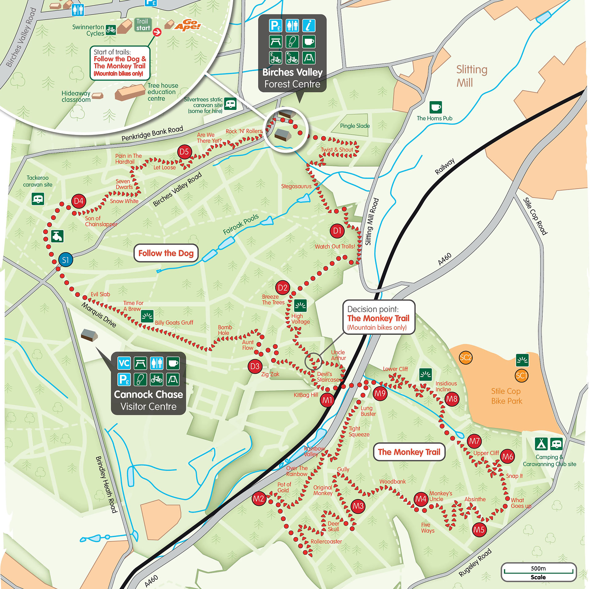
Map of Follow the Dog and the Monkey, the two red-graded trails at Cannock Chase, Staffordshire
For those mountain bikers less interested in the technical rides, family groups, and others wanting a more leisurely way of exploring the area, the tracks that until recently constituted the 22 km Sherbrook Trail, provide a wonderful route. Forestry England have recently ‘decommissioned’ the blue-graded Sherbrook Trail, citing a desire to reduce user numbers in order to protect a ‘fragile environment’. Although the blue waymarks have all been removed, there is no information at the Birches Valley Centre explaining why this action has been taken. This is unfortunate, as the Sherbrook Trail was (or still is, since the route linked up bridleways with right of access for bikes and horses) rather unique in my experience, and at the very least some explanation of how cyclists keeping to the waymarked trail posed a threat to the environment would have been helpful. Instead, the existence of the trail has been more or less erased, which is puzzling especially to those who know Cannock Chase and this particular trail well. Furthermore, Forestry England (on the web link provided above) implies that the new blue trail (Perry’s) provides an alternative; in my opinion this wrong and potentially unwise, as the latter is quite short at just 4.3 km, technical (albeit at blue grade) and narrow – it is therefore completely different from a 22 km non-technical, family friendly trail. Rather than discourage its use, I feel active management of any threats would have been a more appropriate way forward; I am currently trying to find out more about the background to this decision by Forestry England, and will post a new blog when I know more.
For now, this tour takes the bridleways that used to constitute the Sherbrook Trail. After crossing Birches Valley Road and then Penkridge Bank Road, I turned right to Rifle Range Corner (this is marked on 1:25,000 OS Maps); the clue is in the name, of which more shortly. From there, I continued along the Sherbrook trail to the Trig Point at 199 metres, and then went off along a straight track that crosses some of the lovely open heath now widespread on the Chase, with wonderful views westwards across the valley of the Sher Brook.

Lovely riding across the heath heading north-west from the Trig Point at 199 metres
Traces of the Great War at Cannock Chase
In the forest near my heathland track, a short way down Marquis Drive, is an interesting feature marked as an embankment on the OS 1:25,000 map. A long, bare gravel bank runs East-West at this point, with a pool lying on the northern side. This was the barrier for one of the rifle ranges established here for training during the Great War of 1914-18 (First World War).

The embankment at the end of the WW1 rifle range, in the woods between the Trig Point and Haywood Slade
Cannock Chase had been used for military training from the late 19th Century, and a tented camp was established at that time to support exercises. With the outbreak of war in August 1914 recruits needed barracks, and Lord Lichfield made land near Brocton (just across the Sherbrook valley) and Rugeley available to establish more permanent camps. Each of these camps was able to accommodate 20,000 men along with horses and supplies. As the newly recruited men went over to France and Belgium to fight, the camps changed their function in late 1915 to one of training, with ideal open ground, rifle ranges and practice trenches.
Into the Sherbrook Valley
From the open expanses of heath, my wide trail gradually transformed into a steep, sinuous singletrack that descended past clumps of birch towards the valley bottom. I have seen deer in this part, though they are abundant across the Chase and there are frequent warnings to motorists to take care. Soon I was at the Stepping Stones, one of the prettiest features of the whole area. Although it can get very busy on sunny days, especially at the weekends, it is places like this that show why Cannock Chase is designated an Area of Outstanding Natural Beauty (AONB).

Autumn colours at the Stepping Stones crossing of the Sher brook, one of the loveliest spots at Staffordshire’s beautiful Cannock Chase
Turning west towards Harts Hill, I took the path left at a junction and climbed up to the old sand quarry at Mere Pits, where I emerged on a gently curving inclined path which had all the appearance of a disused railway track.
And that was because this was once the ‘Tackeroo Line’, a military railway that ran from Milford Junction just down the steep cutting to my right, all the way up over the heath above Brocton to Brindley Health at the southern end of Cannock Chase. The line took its name from a coal mine located near Brindley Heath.

The curved incline of the old military ‘Tackeroo’ railway that served the WW1 military camps on Cannock Chase
The Camps of Mordor
This railway was constructed in 1915, and served the training camp at Brocton and a 1000-bed military hospital at Brindley Heath. The latter was built in 1916 to care for wounded soldiers returning from the Western Front, and for those falling ill during their time posted on Cannock Chase. After the war, the hospital was used to treat soldiers affected by gas and ‘shell shock’, a condition we now recognise as PTSD. The hospital closed in 1924 and little remains of the original buildings at the site, which is now a business park.
Among those posted to Brocton and Rugeley Camps was Lord of the Rings author J.R.R. Tolkien. Following his marriage to Edith Bratt in March 1916, his wife also came to live nearby in Great Harwood. Tolkien also spent time here recovering from trench foot acquired while serving in the Somme, and it seems that the experience made quite an impression on his literary imagination. Among these possible local associations are the ‘Camps of Mordor’ (the training camps on the Chase), the Brook of Glass (the Sher Brook), and the Forest of Fanghorn (Brocton Coppice). The woodlands around Brocton do indeed feel ancient and magical, while the crystal-clear waters of the stony Sher Brook are perfectly described.
From the top of the Tackeroo incline, there are many options. My explorations recently have taken me towards the Glacial Boulder (near Trig Point 194 metres), an indication of the scene here in the last Ice Age. The underlying geology of Cannock Chase is Triassic Sandstone, although apart from a few sandy sections of the trails, there appears to be little evidence of this rock near the surface. Following a small track through gorse and heather, I came across a small pool, where in the summer iridescent damselflies dart across the inky blue water. It’s a very peaceful spot that has become one of my favourite snack stops.

My secret pool, not far from the Glacial Boulder – it is marked on the 1:25,000 OS map!
Cemeteries remembering the dead of two world wars
A short distance further on, I emerged from the woods to find the Katyn Memorial, which remembers the many Poles murdered on Stalin’s orders at Katyn and other locations, an atrocity denied by the USSR until 1990. It seems that Cannock was chosen for this memorial by Polish visitors who saw the resemblance of the landscape with the forests of Katyn, and recognised the connections already established through memorials to both world wars. This area of the Chase is indeed rich with memorials. One kilometre further south, just beside the road at Cannock Thorn, is a substantial Commonwealth War Graves Commission (CWGC) cemetery, and almost next door on the trail back down into the Sherbrook valley is a German war cemetery.
An information panel at the CWGC site tells the story of these two burial grounds, and more besides. Most of the graves in the CWGC cemetery are of soldiers wounded on the front, and those being treated in the hospital at Brindley Heath. The majority are British and Commonwealth, but also buried here are 286 German prisoners of war who died in the internment camp and hospital. Many of the graves here are of New Zealanders, although interestingly, given the current pandemic we are living through, quite a few were casualties of the ‘Spanish flu’ which was already widespread and taking lives of many young people by 1918.
Commonwealth soldiers from New Zealand had made an important contribution in the Battle of Messines in Belgium in June 1917, a prelude to the infamous Battle of Passchendaele (the Third Battle of Ypres). As the operation had been so successful in pushing back the Germans, men from the 5th Battalion of the New Zealand Rifle Brigade were brought over to Cannock Chase to help train recruits in the evolving methods of trench warfare that had proved so effective at Messines.
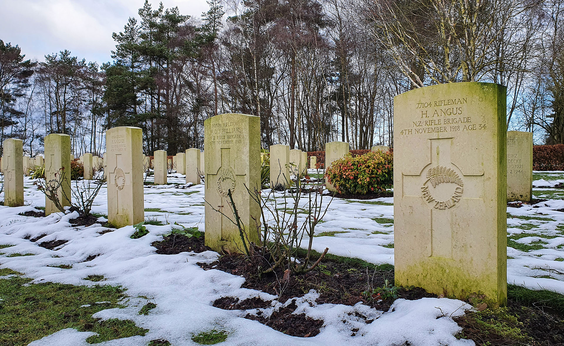
Soldiers from the New Zealand Rifle Brigade buried at the Commonwealth War Graves Commission cemetery near Broadhurst Green

Communal graves for Zeppelin crews shot down over England in WW1
Memorials to a fiery end
A short way down the track leading down to the Sherbrook Valley lies the German Cemetery. Established in 1959, this is the final resting place for all German nationals who died on British soil in both world wars, and who are not buried in CWGC sites elsewhere in the country. I was surprised to find, in a separate section to one side of the cemetery, four communal graves of Zeppelin airship crew killed in Britain during the Great War.
The names of the crews, all of whom have their naval military titles, are listed along with the designation number of the airship. Zeppelin L-48, for example (illustrated here), captained by Franz Eichler, was shot down on 17 June 1917 over Suffolk. Remarkably, three men survived the resulting inferno, the only time during the Great War that crew of a burning airship got out alive.
Sitting for a while in this peaceful location, with a flask of coffee and a snack, I thought about all the reminders of the Great War that I had seen dotted across Cannock Chase – and there are plenty. The rifle ranges, the old Tackeroo Line serving the camps and military hospital, the two cemeteries remembering the dead from both sides, and the link with the terrible battles on the Western Front in Flanders.
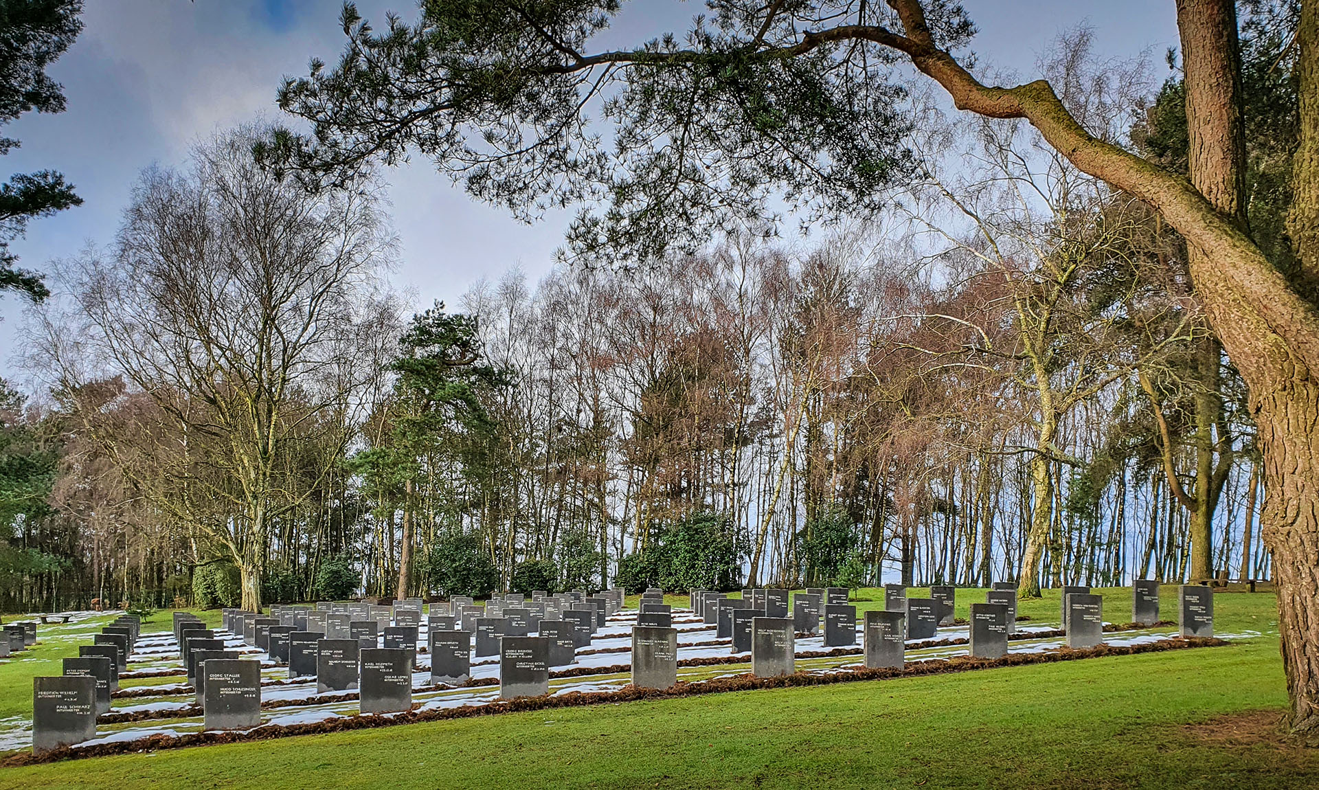
The Cannock Chase German Cemetery, established in 1959 as the burial ground for all German nationals dying on British soil in both world wars, and not buried in other sites
A few years previously in 2016, I cycled along the Western Front of WW1, and the memories of visiting all of those battlefields, including Messines, are still very fresh. In the square at Messines is a very moving sculpture recalling the Christmas Truce of 1916, depicting two soldiers, one British and one German, standing in the mud with a football, about to shake hands. The sculpture was designed by Andrew Edwards from Stoke-on-Trent, a short distance from where I was sitting in Cannock’s German Cemetery.
The Brook of Glass and Abraham’s Valley
From the German Cemetery, I rode down the track to rejoin the Sherbrook Trail which follows the meandering stream, Tolkien’s Brook of Glass, back to the Stepping Stones. On the east side of the ford, the track passes through gently undulating woodland with some wonderful ancient trees to reach the bottom of Abraham’s Valley.
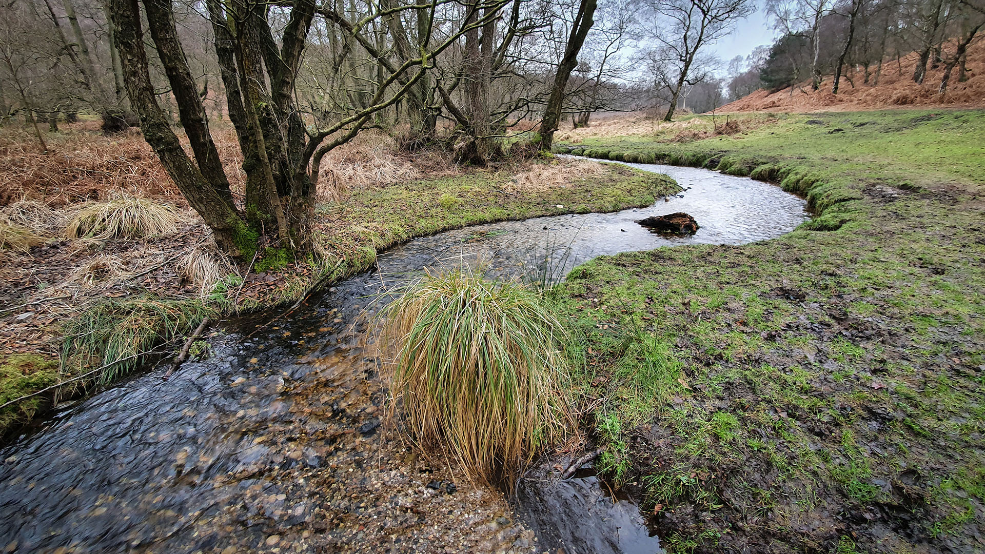
A meandering section of the pretty Sher Brook near Devil’s Dumble

Ancient trees on the Sherbrook Trail between the Stepping Stones and Beggar’s Hill
Abraham’s Valley presents the cyclist with a 2.5 kilometre climb, varying in gradient and moderately steep in some sections. It runs beside a stream known as the Old Brook, but has a quite different character from the much more open Sherbrook Valley, being more wooded. This area is said to be one of the best parts of the Chase for birdwatching, including for residents such as the Great Grey Shrike and Siskin, as well as migratory nesting birds including Wood Larks. On reaching the junction at the top of the hill, you can turn left and loop around by another of the old Great War rifle ranges, or pass by the Trig Point (199 metres) and head back that way to cross Penkridge Bank Road.
A hair of the Dog
Just after crossing the road, I re-joined the Follow the Dog MTB Trail where it crosses the Tackeroo camp site, a name recalling the Great War railway and the old coal mine. That way, I would end up completing all of the interesting sections of the red trail by the time I got back to Birches Valley. There are more very enjoyable technical sections on this last part of the Dog, and I particularly like the serial hairpins of the Seven Dwarfs and the flowing drop-offs at Snakes and Adders.
Alternatively, if you stick to the former Sherbrook Trail paths, this will take you back past the Fairoak Pools, a favourite spot for anglers and which reflect lovely colours of the surrounding trees in Autumn. Just after the pools, it’s fun to splash through the ford across the Stony Brook pretending you are cleaning your bike (it doesn’t work).

The final section of the Sherbrook Trail runs beside the pretty Fairoak pools
2022 Commonwealth Games at Cannock Chase
Cannock Chase will host the mountain biking events at the next Commonwealth Games. The games are centred around Birmingham and due to run from 28 July to 8 August 2022. Preparations at Cannock will see further improvements to the red-graded trails, and have already brought the new Perry’s Trail. Graded blue, this also starts at Birches Valley, and offers a very enjoyable fast and flowing route – if you can get the lines right! This new trail is part of the legacy investment required of the games, and is designed to encourage people to try more technical mountain biking and develop their skills on a fun route that is not too demanding or scary.
See you there!

The new blue Perry’s Trail recently completed at Cannock Chase has flowing berms which will test your ability to get the right line
My ‘Magic Rides’
This is the second in my series ‘Magic Rides’, adventures by road or mountain bike that have that special something beyond just the cycling, and which left me with a feeling of wonder and magic. It may be the landscape, beautiful light, a rich variety of wildlife, interesting architecture or fascinating history that cast the spell. In most cases, it will be something of all of these.
Comments and shared experiences of the trails, wildlife, history and other aspects of Cannock Chase welcomed!
- All photos © Nigel Bruce
- My bike route map from Garmin Connect
- The Cannock Chase MTB Trail map is available to download from Forestry England



Trackbacks/Pingbacks